


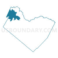
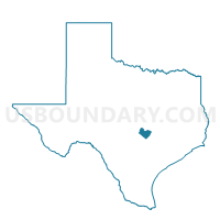
Voting District 0371, Travis County, Texas
About
Outline

Summary
| Unique Area Identifier | 677797 |
| Name | Voting District 0371 |
| County | Travis County |
| State | Texas |
| Area (square miles) | 66.17 |
| Land Area (square miles) | 62.13 |
| Water Area (square miles) | 4.03 |
| % of Land Area | 93.90 |
| % of Water Area | 6.10 |
| Latitude of the Internal Point | 30.53630780 |
| Longtitude of the Internal Point | -98.02963720 |
Maps

Graphs
Select a template below for downloading or customizing gragh for Voting District 0371, Travis County, Texas


Neighbors
Neighoring Voting District (by Name) Neighboring Voting District on the Map
- Voting District 0006, Burnet County, TX
- Voting District 0021, Burnet County, TX
- Voting District 0308, Travis County, TX
- Voting District 0370, Travis County, TX
- Voting District 0372, Travis County, TX
- Voting District 0373, Travis County, TX
- Voting District 0375, Travis County, TX
Top 10 Neighboring County Subdivision (by Population) Neighboring County Subdivision on the Map
- Northwest Travis CCD, Travis County, TX (96,420)
- Southwest Travis CCD, Travis County, TX (53,442)
- Marble Falls CCD, Burnet County, TX (22,376)
Top 10 Neighboring Place (by Population) Neighboring Place on the Map
Top 10 Neighboring Unified School District (by Population) Neighboring Unified School District on the Map
- Leander Independent School District, TX (146,557)
- Lake Travis Independent School District, TX (36,287)
- Marble Falls Independent School District, TX (23,431)
- Burnet Consolidated Independent School District, TX (22,039)
- Lago Vista Independent School District, TX (8,418)
Top 10 Neighboring State Legislative District Lower Chamber (by Population) Neighboring State Legislative District Lower Chamber on the Map
- State House District 47, TX (198,311)
- State House District 54, TX (196,447)
- State House District 48, TX (161,817)
Top 10 Neighboring State Legislative District Upper Chamber (by Population) Neighboring State Legislative District Upper Chamber on the Map
Top 10 Neighboring 111th Congressional District (by Population) Neighboring 111th Congressional District on the Map
Top 10 Neighboring Census Tract (by Population) Neighboring Census Tract on the Map
- Census Tract 17.65, Travis County, TX (12,976)
- Census Tract 17.66, Travis County, TX (6,767)
- Census Tract 9608, Burnet County, TX (5,791)
- Census Tract 17.64, Travis County, TX (5,789)
- Census Tract 17.79, Travis County, TX (5,715)
- Census Tract 17.80, Travis County, TX (3,825)